Follow Us x

Battle Mountain History
As the Central Pacific Railroad Company swiftly laid tracks from west to east coast across Nevada in the late 1860's, the company designated its main stations at Reno, Wadsworth, Winnemucca and Elko as well as a station at Argenta. In the autumn of 1869 a new town, Battle Mountain, sprung up from the relocation of the Argenta Depot. The settlement depended on the railroad for its prosperity, and on the mines that boomed and busted all the way from the Reese River Valley to Austin, 90 miles to the south.
In 1880 the Nevada Central Railroad was completed through the length of the Reese River Valley to the south connecting Austin with the transcontinental line; the following year, a short line was built to Lewis Canyon, but it only lasted one short year.
The town may have owed its name to the Battle Mountain Mining District, but not its economy. Unlike other Nevada towns, Battle Mountain did not die when its namesake district shut down. With its strategic location on the railroad and near the intersection of the Humboldt and Reese Rivers, the town became a supply and shipping hub for a large part of north-central Nevada, and soon all roads did lead to Battle Mountain.
By the Middle 1930's, most of the mines shut down and were boarded up and the Nevada Central had passed into receivership for the last time.
In the late 1960's, Battle Mountains 30 year hiatus ended abruptly when the Duval Company invested more than $20 million in the development of large copper ore bodies in the hills to the south.
All at once Battle Mountain became a boomtown in its own right, causing the Nevada Legislature to move the seat of Lander County from Austin to Battle Mountain in May of 1979.
During the 1980's, the town revolved around the mining of Barite, a heavy compound used in oil production. Today, Lander County's largest city ( Battle Mountain) is one of the world's richest gold-producing areas.
Even so, there are many cultures and industries that have left their mark over the years, including the Western Shoshone Native Americans, the Basque Sheepherders and the Cattle Ranchers and Farmers who make their homes here.
Today, Battle Mountain's Population is Approximately 4,000 and the elevation is 4,511 ft. The town lies at the heart of one of the world's largest gold-producing centers; Mining and ranching are both central to the local economy. Tourism and gambling also help provide economic diversity.
Battle Mountain Cookhouse Museum
The Hub for Culture, History and the Arts in Battle Mountain
Housed in a restored late 1920's ranch cookhouse, the Battle Mountain Cookhouse Museum is the area's first museum dedicated to the exhibition and preservation of regional history. In addition to displays of area artifacts, the Cookhouse Museum also hosts traveling cultural exhibitions, traditional and contemporary local art and a diverse array of cultural events including poetry and author readings, storytelling and artist's talks. The Museum building was moved from the 25 Ranch, once belonging to the W.T. Jenkins family. It served as a cookhouse and in later years as a bunkhouse.
Located on Broyles Ranch Road just off interstate 80, the bright red Cookhouse Museum offers various displays of local Native American and Chinese artifacts. The Museum captures the pioneer spirit of Lander County's first residents with snapshots of history: vintage kitchen ware, eyeglasses, formal clothing, antique cameras, school equipment, ranching tools and so much more.
The Lander County Historical Society's next exciting venture will resurrect the fond memories of the Battle Mountain Train Depot that was built in 1880 and demolished in 1988. This new building will resemble the Depot. It will allow expansion of the current galleries, provide additional space for community and visitor events, while highlighting the important role ranching, mining, and the railroad played in the development of Battle Mountain and the Silver State. This project will enhance and strengthen the already successful museum and will increase opportunities to welcome more visitors to our community and ultimately showcase our local history.
Take a step back in time into age-old memories. Visit the Cookhouse Museum!
Open Tuesday - Saturday from 12:00 - 4:00.
Ghost Towns & Mining camps
Please remember to exercise caution when exploring Nevada’s Ghost Towns & Mining camps. Open shafts, drifts going into mountainsides, and old buildings, are all DANGEROUS! Be aware of your surroundings and let someone know where you are, especially if your plans change. Also some of the property is privately owned, please gain permission before entering. Please do not attempt to drive to these locations without 4 wheel drive or an ATV.
Battle Mountain
TENABO
A rush immediately developed after silver and gold ore was discovered during the summer of 1906. A town site was platted and by 1907 Tenabo had a population of 1,000. The residents supported a wide range of businesses including restaurants, hotels, assay office, grocery store, lumberyard, a school, and many saloons. A mill was built in nearby Mill Gulch. By 1909, most of the mines were controlled by the Tenabo Mining and Smelting Company. However, by 1911 the cost of producing the ore became higher than the value of the ore. The post office closed in 1912 and Tenabo quickly declined. The Tenabo mining and Smelting Company sold all of its holdings in 1920 after producing 12 million ounces of silver and 25,000 ounces of gold. Today, the property is actively being worked by the Flowery Gold Mines Company of Nevada. People still live in the camp where wooden buildings stand at the town site.
Hilltop
The town of Hilltop began in 1906 when prospectors discovered gold ore very close to the original discoveries of the 1860s. The Hilltop boom really got under way in 1908 and by 1909 there were 200 people living in Hilltop. The town itself was well developed with several fine houses, a school, numerous stores, and saloons. By 1912, mining activity was in full swing. Hilltop’s population varied greatly during the teens. By 1918, mining had slowed greatly and only about 50 residents were left. Various companies conducted operations during the period from 1920 to 1927 with various degrees of success. Hilltop still had about a dozen residents during the 1930s but by 1940 it had become a true ghost town. The remains at Hilltop are quite extensive. One could easily spend a full day exploring one of the best spots in Lander County.
Galena
Before the buildings collapsed and the grave yard swelled, Galena was an old mining town rich with life and opportunities. In 1863 silver, gold and lead were discovered: the first camp was formed three years later. One hundred residents lived in Galena by 1868, and two years’ later the town was platted. The streets were soon crowded with stores, saloons, a town hall and a town watering system. By this time, Galena had a greater population than its neighboring Battle, Mountain. With a population of several hundred, Galena was in competition with Winnemucca for the county seat. However, when the Galena Range area was ceded to Lander County in 1874, seat dreams were shelved, because it was the same county as Austin, and even richer and larger town.
In 1871 Galena opened its first post office, which was run by B.F. Blossom for 12 years. With a population rise of 250 people, 100 being miners, the town now supported 2 hotels, four mercantile stores and 2 stage lines, Tuller and Cluggade and the Filippini which cost $3 each way, running from Galena to Battle Mountain.
During the early and mid-1870’s, mining increased but by the early 1880’s, mining activities slowed dramatically. After a huge fire in 1889, Galena’s mining activity ended for the most part. Today Galena is a quite ghost town with remnants of its prosperous past scattered throughout the canyon. For anyone wanting to visit and take pictures of a old mining town , Galena canton can be located 10 miles south of Battle Mountain on St Highway 305, turn right following the dirt road for 3 miles to Galena Canyon.
Bunker Hill
Ore discoveries were made at Bunker Hill in 1863. In 1864, a mill was built at nearby Kingston that treated ore from the Bunker Hill mines. There was growth and activity at Bunker Hill that attracted a small camp. Some stone cabins were built but before substantial development could take place Kingston became the main settlement. Bunker Hill then became mainly a scene of mining activity with practically no permanent inhabitants. The mines were active until the mill closed in Kingston in 1869. A few stone remains still exist at Bunker Hill along with mines and other ruins. The setting is inviting, and with a wooded campground you can plan to stay and explore for a day or two.
Carter's Monument
In 1879, a 60 year old unemployed carpenter built a stone wall over a mile long at Stoney Point as his personal memorial to the struggles of the California bound pioneers. “That monument is as lasting as the hills. It is the work of a master hand, a landmark for our youth; one that will have a place in our memory when their heads are bowed down with old age, and the sit around the firesides of their children telling tales of the frontier; and among them will be the Humboldt River, Rocky Point, and that stone fence up the mountain, four feet high and two miles in length, built by Hirum M. Carter, and known as “Carters Monument.” The monument is about seven miles north east of Battle Mountain, at Stoney Point.
Directions
It is approximately 10.4 total miles to the Monument. Please note the road conditions before traveling. Use a 4 wheel automobile and bring plenty of water.
Starting at the North edge of town on Reese Street ( by the Battle Mountain Livestock & Events Center), Go 5.6 miles to the railroad tracks and immediately turn right onto the paved road. At about 6.2 miles the pavement ends, and about 6.8 miles the road forks; keep to the left. At 7.9 miles you arrive at the Old Coastal Chemical Plant. Drive on past the entrance, heading south, toward the railroad tracks. On the left is a wooden sign marking the California Trail. Just past the sign the road will turn left, going between the old chemical plant and the railroad tracks. From here the road is not well maintained and you need to be careful of deep ruts and/or mud, depending on the time of year. Just as you pass the chemical plant, the road forks; take the left hand fork, crossing the railroad siding tracks.
At about 9.9 miles you will see a Trails West trail marker on the right side of the road. This is the Stoney Point Marker (#C-53). From this point you can see the stone wall as a faint line just below the crest of the hill immediately ahead of you. At about 10.2 miles you will be immediately below the beginning of the wall, but this is not a good place to stop as it is a narrow blind stretch of the road. Continue on about 10.4 miles where there is more room to park. You can either walk back along the road or climb up the hill to the power-line road about 75 feet up the hill and the walk back to the beginning of the wall, just around the hill.
Shoshone Indians
The Battle Mountain Band of the Te-Moak tribe of Western Shoshone Indians has added to the rich heritage that this area enjoys.
Hundreds of years ago, the Battle Mountain region was the boundary area between the Newe (the ancestors of the Shoshone) and the Northern Paiutes; it was known to the Newe as "Tonomudza." Several Newe bands lived in the area, which was a focal point for rabbit and antelope drives. An influx of whites soon claimed the fertile regions along the Humboldt and its tributaries. The 1870s saw the coming of the Central Pacific Railroad and the founding of Battle Mountain. After the 1880s , the Newe continued to live on the outskirts of the town, and some found work on the ranches.
By 1917, the colony received official recognition for their lands. In the 10930s the Colony began building residential homes and a community development with the purchase and renovation of houses from the Getchell Mine near Winnemucca.
While the tribe's lifestyle has changed dramatically over the centuries, tribal leaders say they continue to acknowledge their deep connection to the land. Shoshone members continue to hunt, fish, pray and gather materials from the Newe Sogobia ("Earth Mother").
As modern-day basket weavers, tribal members gather together on a regular basis to ensure traditional knowledge and skills are shared and taught to sustain their relationship with the earth.
The Battle Mountain Colony has its own tribal council and operates a smoke shop/convenience store with plans for a truck stop as well. In addition, the community building was renovated and a playground, park, and picnic grounds were added. A senior citizens center is also located on the reservation as well as a newly added activity center.
Walking Tour
Take a Stroll Through History
1. 855 Broyles Ranch Road
The Battle Mountain Cookhouse Museum
This building owned by W.T. Jenkins family, served as the cookhouse and bunkhouse for the 25 Ranch, in the 1920's and 1930's; it was moved to its current location in the late 1990's. The museum is open from 10 a.m. to 2 p.m. Tuesday through Saturday. Call (775) 635-8548 for more information.
2. 4th & Mountain Streets
Old Mortuary Buildings
The Old Mortuary included a building that housed a horse-drawn carriage that was used for funerals.
3. 315 Humboldt Street
Battle Mountain Grammar School/Lander County Court House
Built in 1916, designed by architect Fredrick Delongchamps. It was even equipped with a state of the art vacuum system. It became the L.C. Courthouse in 1979 then deserted in 2017.Work is in progress by a local group to restore in to its original glory.
4. 54 W. 4th Street
Filippini House
One of Battle Mountain's original settlers, Bonner Cole, owned this house. It was moved into town from the "New Hilltop" area.
5. 45 E. 4th Street
Grace Presbyterian Church
This church's bell was donated by Mrs. Louse Marvel (daughter of W.T. Jenkins).
6. 384 S. Reese Street
St. John Bosco Catholic Church (2nd Church)
Originally established as Sacred Heart in 1897.
This church that is now standing was built in the 1937 and was dedicated to St. John Bosco. It has since been updated with antique stained glass windows and a hall across the street for larger functions.
7. 190 E. 3rd Street
Adams House
This house was built in 1906 and was used as the Episcopal Church parsonage.
8. 285 E. 3rd Street
The design of this home and the one at 292 E. 2nd St are exact replicas of one and another.
9. 292 E. 2nd Street
Ancho House
This house was a dental and medical office at the Tonopah Air Base. When it closed, it was moved to Gold Acres Mine in the 1950's. When the small mine closed in 1963, it was moved to Battle Mountain and placed on a basement.
10. 270 E. 2nd Street
Dorian House
This house was built around 1910 by Robert Taylor and owned by Constance and Henry Dorian
11. 232 E 2nd Street
Water Tower House
Owned by Mr. Treat and built by Robert Taylor around 1910, the Water Tower House accommodated excess guests from the Nevada Hotel.
12. 215 S. Broad Street
Eleanor Lemaire House
Mr.Kottke built this house in 1916 for Kate and Louis Lemaire.
13. 105 W. 2nd Street
Johnson House
This house was built in the early 1900's with lumber from buildings from the "New Hilltop" area. It was once owned by Rene Lemaire, a state senator,
14. 152 W. 2nd Street
United Methodist Church
This church was built in 1893 by early settlers who brought the foundation stones from the surrounding hills for the foundation. The parsonage was added in 1953.
15. 6 W. Front Street
Lemaire Store
Originally built by John Williams in 1876, this store was remodeled in 1879 by A.D. Lemaire. It remained in the family until 1984 (105 years) It was also the home of Battle Mountain's famous "Pete's Chorizo" until Pete moved his business to Carson City.
16. 36 E. Front St.
Nevada Hotel
It opened in 1872 by Adam and Margret Altenburg. It stayed in the family for 9 Decades. Current Owners are Dorians
17. 72 E. Front St.
Owl Club/ Horton Mercantile
Built about 1877 and bought in 1904 by the Horton family. It encompassed several buildings. Horton Mercantile Co., was a coal yard as well as a hardware store, and is now Battle Mountain's largest casino, the Owl Club Casino, Restaurant & Motel.
18. Broad Street ( behind Welcome to Battle Mountain sign)
Huntsman Cottage
L.D.(Dow) Huntsman owned this home. It was built in the 1900's. He also was the owner of Capitol Hotel, which burned to the ground twice.
19. 643 N. 1st Street
Hancock House
The Hancock House was built in 1870. L.D. Huntsman's son-in-law , Crebo Hancock owned the house, he was married to Emma Huntsman; it is now home to the Nelson family.
20. 685 N. 1st Street
Hinman House
The Hinman House was built in 1918 as a boarding house by Mr. and Mrs. Dusang, and then expanded after the Williams family purchased it. Hinman's bought it in the late 1950's.
21. 745 N. 1st Street
Marvel House
The Marvel House was built in 1918 for W.T Jenkins. Mrs. Louise Marvel was his daughter. One of her sons was Assemblyman, John Marvel.
Drive by this house to see how well it has been maintained.
22. 775 N. 1st Street
Saval House
The Saval House was built in 1900 for Elvira MacDonald. It was purchased in 1924 by Joe Saval.
23. 831 N. 1st Street
Neely House
This two-room house was originally built in 1907 for Mr. James Horton.
He owned Horton Mercantile Co., a coal yard as well as a hardware store, which is now Battle Mountain's largest casino, the Owl Club Casino & Restaurant.
.jpg)
Johnson House
This house was built in the early 1900's with lumber from buildings from the "New Hilltop" area. It was once owned by Rene Lemaire, a state senator.
.jpg)
The design of this home and the one at 292 E. 2nd St are exact replicas of one and another.
.jpg)
Ancho House
This house was a dental and medical office at the Tonopah Air Base. When it closed, it was moved to Gold Acres Mine in the 1950's. When the small mine closed in 1963, it was moved to Battle Mountain and placed on a basement.
.jpg)
Saval House
The Saval House was built in 1900 for Elvira MacDonald. It was purchased in 1924 by Joe Saval.

.jpg)
Adams House
This house was built in 1906 and was used as the Episcopal Church parsonage.
.jpg)
Ancho House
This house was a dental and medical office at the Tonopah Air Base. When it closed, it was moved to Gold Acres Mine in the 1950's. When the small mine closed in 1963, it was moved to Battle Mountain and placed on a basement.
.jpg)
Dorian House
This house was built around 1910 by Robert Taylor and owned by Constance and Henry Dorian
.jpg)
Eleanor Lemaire House
Mr.Kottke built this house in 1916 for Kate and Louis Lemaire.
.jpg)
Filippini House
One of Battle Mountain's original settlers, Bonner Cole, owned this house. It was moved into town from the "New Hilltop" area.
.jpg)
Originally established as Sacred Heart in 1897.
This church that is now standing was built in the 1937 and was dedicated to St. John Bosco. It has since been updated with antique stained glass windows and a hall across the street for larger functions.
.jpg)
Neely House
This two-room house was originally built in 1907 for Mr. James Horton.
He owned Horton Mercantile Co., a coal yard as well as a hardware store, which is now Battle Mountain's largest casino, the Owl Club Casino & Restaurant.
.jpg)
Grace Presbyterian Church
This church's bell was donated by Mrs. Louse Marvel (daughter of W.T. Jenkins).
.jpg)
Saval House
The Saval House was built in 1900 for Elvira MacDonald. It was purchased in 1924 by Joe Saval.
.jpg)
Water Tower House
Owned by Mr. Treat and built by Robert Taylor around 1910, the Water Tower House accommodated excess guests from the Nevada Hotel.
.jpg)
Old Mortuary Buildings
The Old Mortuary included a building that housed a horse-drawn carriage that was used for funerals.
Which Battle?
That name - "Battle Mountain"- has intrigued Nevadans and visitors for decades. Perhaps the most frequent question about this small town in the heart of Nevada centers on the origin of its name. The easy answer is that the town was deliberately named for the mining District that had been established in 1866 in the hills a few miles south of the railroad's planned route. That answer is not entirely satisfactory, however. Another story involves a man named George Tannehill, who arrived in Austin to show off some copper ore he had found about four miles south of the Humboldt River, his discovery lead to the establishment of the Battle Mountain Mining District. Years after Mr. Tannehill's discovery, an article from the Austin newspaper stated "The discoverer named the district Battle Mountain District, from the circumstance of a bloody battle having been fought there nine years ago between a party of twenty-two immigrants, under the command of Captain Pierson, now living on Reese River, and a large force of Piute Indians-Tannehill being one of the victorious immigrants.
Unfortunately, the district's founders did not leave precise records to explain the name's origin. Complicating that lack of documentation are the variations in the stories that attempted to explain it over the years. The name is more evocative of the continuing complicated relationship among the people who lived in and traveled through the Humboldt River Valley than of a specific conflict with recognized combatants. This lack of specificity encompasses all of the struggles-all of the Battles- that have marked the history of this particular area. The name also reflects the theme of battling the elements to create homes and community on the inherently inhospitable spot where Battle Mountain settled- a flat piece of ground far from water and shade. Battle Mountain residents worked hard to shape their new town- building homes and businesses and rebuilding them when they burned or were blown down by strong winds; Early Battle Mountain residents relished their standing as fighters. Sometimes winning; sometimes losing-to build and sustain a community out of little more than steel tracks and dusty rocks
Did you know?
The Native Americans: Here the Territories of three separate tribes converged; to the west, the Northern Paiute: to the east, the Western Shoshone: and to the north, the fearsome Bannock.
Fur Trappers and explorers: Peter Skeen Ogden and John Work of the Hudson Bay Co., Joseph Walker and John C. Freemont all came this way, following the Humboldt River.
The early emigrants: Between 1841 and the discovery of gold in 1848, over 2,700 people traveled to California along the Humboldt River. The most notable group was the Bartelson-Bidwell Party, the first party of emigrants to make this fearsome trip, included a 18 year-old Nancy Kelsey, pregnant and carrying her 6 month old daughter. The ill-fated Donner Party also came through here on their way to the snow-covered Sierra.
The 49ers: Over 200,000 people came through here on their way to California and the gold fields of the Sierra. Stony Point, just north of town, was famous (notorious) landmark on the trail, and the site of three attacks in 1857 that could be the basis for Battle Mountain’s name.
The Transcontinental Railroad: In 1868 the Central Pacific Railroad, the western half of the Transcontinental Railroad that connected Sacramento with Omaha and points east, arrived in Battle Mountain, on the way to meeting the Union Pacific Railroad at Promontory Point. For years, the two story 50-room, Capitol Hotel in downtown Battle Mountain was a meal stop for the trains. It was also the site of the very first women’s suffrage meeting ever held in Nevada, on July 4, 1870.
Early Aviation: Battle Mountain was a stop on the very first transcontinental air race, held in 1919, one leg of which was won by a flyer from Battle Mountain. In 1929 the first airmail beacons were installed along the Humboldt River and Battle Mountain became an emergency field. In 1931 Amelia Earhart landed here in her Pitcairn PCA-2 Autogyro en-route to California just after setting a new world’s record. And during WWII Battle Mountain was a reserve field for the bomber base at Wendover. Where crews trained to drop the atomic bomb.
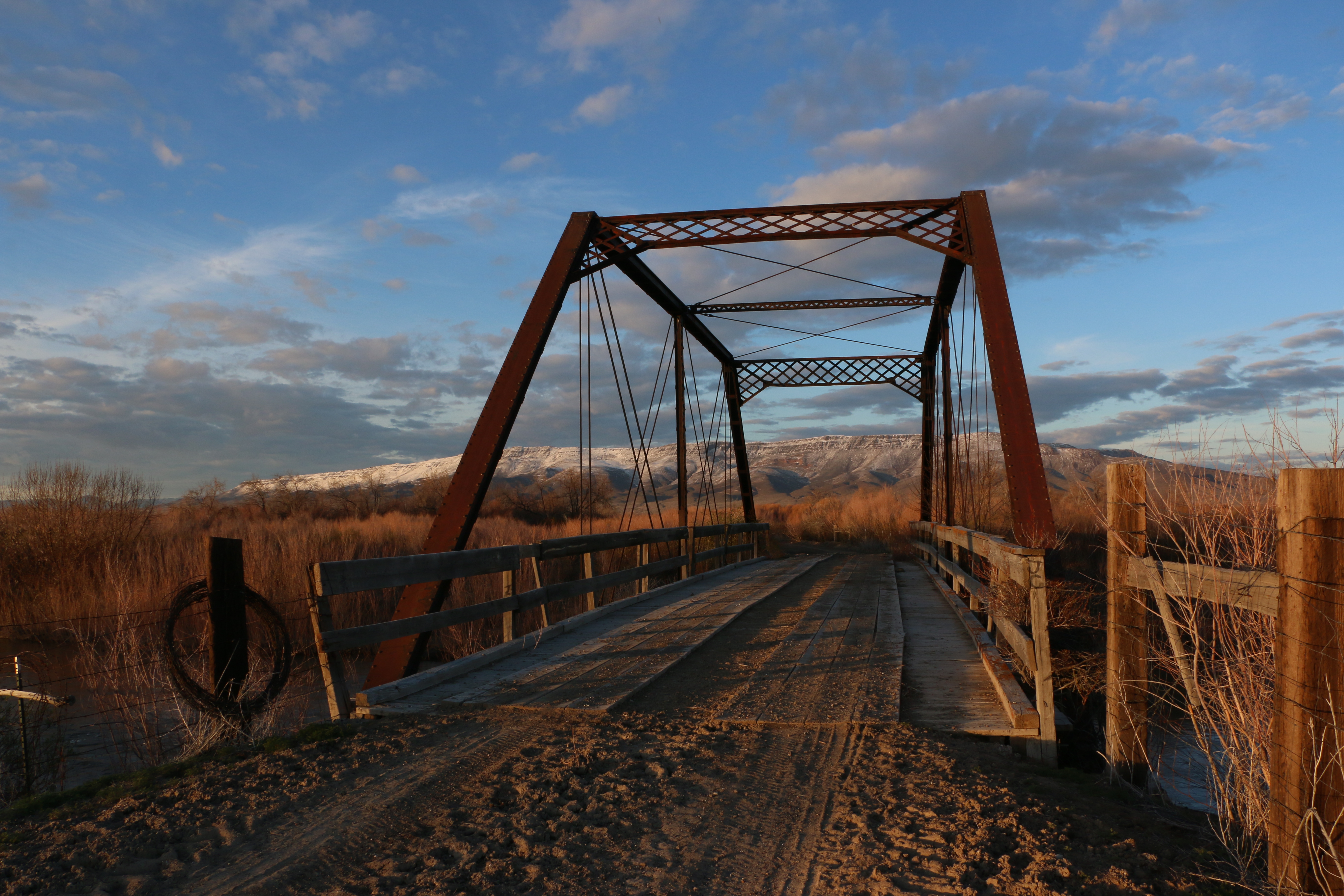
All Roads Lead to Battle Mountain: Despite the rough and barley-ready roads, Battle Mountain folks enthusiastically acquired an increasing number of motorized vehicles and worked hard to improve the roads that led to Battle Mountain. In 1908, C.H. Snow started his auto stage line between Battle Mountain and Gold Circle, traveling north from Battle Mountain over the recently-completed Black Bridge. Pictured on the Black Bridge in the early 1900’s is local school teacher Eliza Pierce. 2nd picture is current day Black Bridge, property is now privately owned and the road is closed to through traffic.
Travel Nevada