Follow Us x
Recreation

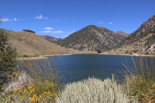
Groves Lake was constructed in 1969 and after leaking for several years, the dam was resealed in 2000. The lake was created specifically for recreational use and lies in a beautiful, narrow canyon.
Pertinent Information
At maximum capacity, the lake covers 16 surface acres and stores 184 acre-feet of water. Maximum depth is 22 feet. The lake, one of very few in the area, is a favorite of local anglers. Angling use averages about 4,500 angler days annually. The lake has a put-and-take fishery for rainbow trout that average 8 to 12 inches. It also supports a fair number of brown trout that inhabit and naturally reproduce in Kingston Creek above the reservoir. Brown trout are typically an aggressive feeder and the use of spinners or flies will increase your chance of catching one. Larger brown trout are occasionally captured such as the 12-pounder taken in 1978. Kingston Creek below the reservoir is also a great place to pick up small browns. A normal selection of worms, Power Bait, lures, and flies will catch both browns and rainbows. Camping is in designated Forest Service campgrounds along Kingston Creek below Groves Lake. The nearest services can be found in Kingston, a small town 3 miles below the reservoir. There is free camping in the canyon at the Forestry camp ground and around the reservoir, Groves Lake. Kingston is an excellent gateway to the Toiyabe Crest Trail and Arc Dome Wilderness.
Stocking
The lake is stocked in the spring and early summer with up to 3,000 rainbow trout.
Regulations
Open year around, any time of the day or night. The limit is 5 trout.
Boating Regulations
Only vessels without motors and vessels which are powered by electric motors are permitted on Groves Lake.
Access
Travel US Route 50 to State Route 376, continue for 16 miles traveling south until turning west at the Kingston Road junction. A Forest Service road runs the 5 miles along the creek through Kingston to the lake. The roads are usually open to travel by late April or early May.
Spencer Hot Springs
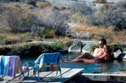
Hot springs, filled with steaming, soothing mineral water are a popular way to sooth away the aches and pains after a days of hiking, riding, and other activity. Spencer is a cluster of natural springs on unimproved public land. Previous visitors have made some rudimentary improvements to the area to enhance the experience. The largest "bathing hole" has water of about 140 degrees flowing into a concrete tub. There is no fresh water, restrooms, or amenities. Visitors may park nearby in their campers or RVs or just drive out for a soothing soak before settling in one of the neighboring towns for the evening. If you do decide to camp out there, PLEASE be courteous and not camp right on the springs so other people and wildlife can also use the springs.
Directions: Located off SR376, just east of the junction to Highway 50. Watch for the turn-off near mile marker 99, take the dirt road approximately 10 miles. The Springs are to your left.
Caution: Always test the water before you commit. Hot springs can change temperature without notice and every hot spring is unique. Do not endanger yourself by staying in hot water too long. If you think the water's too hot, stay out or wait for it to cool. More than half of hot springs found on public lands in Nevada are hotter than 140š Fahrenheit (skin is scalded within three seconds in 140š water). However, while extreme hot water is one serious danger posed by hot springs it is by no means the only danger. Others include loss of consciousness from chemical fumes, cuts from sharp rocks or broken glass, and bacterial infections. ALWAYS WATCH CHILDREN.
Toquima Cave
Toquima Cave is not really a cave, but a prehistoric rock shelter formed from volcanic rock. This "cave," however, provides you with a rare opportunity to glimpse into the lives of ancient peoples of western America. Through the rock art found in Toquima Cave, these people worshiped and recorded their history and important stories.
Even today, Native American Indians acknowledge a belief in the sanctity of rock art. According to Indian tradition, rock art was located in places of spiritual power where, with the aid of images themselves, their shaman could communicate with the spirit world. A majority of pictographs in Toquima Cave are finger paintings. However, other applicators might have included: human or animal hair brushes, sticks, chewed twigs, grasses, split bones, feathers, fur, moss, or leather.
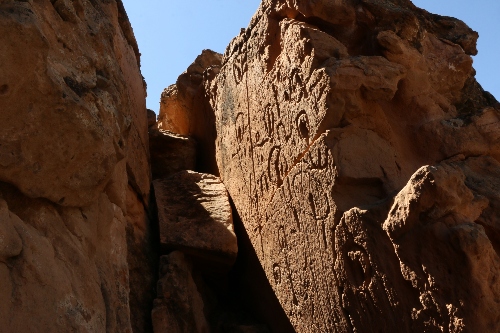
Hickison Petroglyphs
This BLM managed site gives visitors the fascinating opportunity to get in front of 10,000 year old rock carvings! Petroglyphs or rock engravings are images typically carved into stone surfaces, differing from pictographs which are merely drawn onto stone surfaces. Right off of Nevada's infamous Highway 50 lays Hickison Summit Recreation Area. The site, which sits about 6,500 feet above sea level, is positioned on the edge of Monitor Valley in Nevada's Great Basin, at the end of the Toquima Mountain Range. Named after ranch owner John Hickison, the petroglyphs in this region are scrawled across three large slabs and are evidence of prehistoric hunting and dwelling sites dating all the way back to 10,000 B.C. In addition to the self-guided, half-mile hike throughout the site that takes you through multiple petroglyph panels, Hickison Recreation Area includes 16 campsites, a day use picnic area, pit toilets, barbecues and trash facilities. Best yet, the 360-degree view from Hickison Summit is nothing short of remarkable!
Travel Nevada